Like many others, our travel plans in 2020 were derailed by the pandemic. Neither of us had cancelled our vacation request for the end of October, though, so we adapted our plans (two or three times) and settled on an itinerary that would keep us closer to home. Instead of meeting up with our friends in Zambia for a two week safari/road trip adventure in their Land Cruiser, we packed our camping gear into the Mazda 5 (named the Wish 5 after our van in NZ) and headed to the eastern side of California, a place neither of us had spent much time. At the end of October, the number of COVID cases in California was still low, particularly in our county and the counties we were traveling to, so we felt okay about leaving our bubble. With the exception of a toilet, we are pretty self contained in the Wish 5 so knew our interactions with other humans would be relatively minimal.
As if the pandemic was not enough, Pete suffered a thunderclap headache a couple days before we were supposed to leave for our trip. He got another major headache the day we were supposed to leave, so instead of heading east, he spent the day in the ER getting tests to confirm he had not suffered a brain aneurysm. Even with the "all clear" from the doctors, we were a bit hesitant about going to a relatively remote area of the state where hospitals are few and far between and some of our intended destinations were at considerable elevation. We waited a few days to allow Pete to recover from the lumbar puncture and ensure he did not have any additional headaches. Meanwhile, I figured out where the nearest hospitals were throughout the trip and identified alternate modes of communication in areas where cell service was likely to be limited. We did a trial outing up the coast to make sure Pete could comfortably sit in the car and walk up and down hills. With a short outing under our belts, we felt like it was worth giving the trip a try.

We spent our first couple of days near Mono Lake where the air had been consistently clear of wildfire smoke that had plagued large portions of the state for months. The east side of the state is considerably colder than the coast at the end of October, so we were happy we had flannel sheets AND down sleeping bags. The temperatures cooled quickly from daytime highs near 70F to nighttime lows of 20-25F when the sun went behind the mountains, so our dinners tended to be early and relatively quick affairs. Given our recent brush with wildfire and major fires still burning nearby, lighting a campfire was not allowed nor of any interest. Good books and early bedtimes featured prominently in our trip.
While near the lake, we hiked up Lundy Canyon, which was still showing off its autumn colors. The people we encountered on the trail were courteous with distance and most everyone wore masks. We were not sure what the vibe would be, so were pleasantly surprised that people were being cautious.


We could see Mono Lake from our campsite, so a trip to see the tufa was in order. Mono Lake, an ancient saline lake, was once much deeper than it is now, but diversions started in the 1940s to provide water to the ever growing Los Angeles population. The tufa that are now visible and a visitor attraction were formed under water from the unique water chemistry (calcium carbonate), as well as the accumulation of millions of larval cases from brine-loving organisms such as the alkali fly. In addition to the flies, brine shrimp and birds call the lake home. We had a nice time geeking out over the piles of brine shrimp, salt crystals, and fly-chasing birds.

We continued south and took advantage of a rare smoke-free day in Mammoth to hike to Crystal Lake. Just as we arrived at the lake and began eating our lunch, the smoke from the Creek Fire started to crest the ridge and the light turned a familiar smokey orange. By the time we made it back to the car, we could hardly make out the ridge line as the smoke poured back into the valley. After a quick soak in one of the areas many natural hot springs, we kept heading south to try to stay ahead of the smoke.


The White Mountains and the ancient bristlecone pines was our next stop and primary driver for the trip. While we had both seen bristlecone pines in other areas, neither of us had been to the this area containing both the oldest and largest trees in the world. The density of trees is highest at around 10,000 feet, so we did a short hike at the lowest elevation trail possible to make sure it would not incite a headache for Pete. All was well, so we continued up the dirt road to 11,500 feet to the Patriarch Grove, which contains the largest bristlecone pine. The landscape at that elevation was bleak and barren, but it was great to see so many baby bristlecones taking hold. With climate change, there is concern that these trees will run out of habitat as they continue to move up in elevation and are outcompeted by other pines that typically do better at lower elevations, like the lodgepole pine. Bristlecone pines are incredibly long-lived and are quite difficult to age due to their slow growth and gnarled shape. Contrary to other trees, the shorter more gnarled trees are likely to be the oldest trees, rather than the tallest trees. The tall trees are often toppled in drought, fire, and wind, while the gnarled trees withstand adversity for thousands of years. The oldest known living bristlecone pine, clocking in at over 4,000 years old (!) is called the Methuselah tree, but it is unmarked. There is fear that calling attention to the tree would likely result in a human destroying it. Sad, but probably true. We had a beautiful, deep blue sky day, which served as a lovely contrast to the white and amber hues of the often nearly barren trees.


that other trees have a difficult time growing in

Our next point of exploration was the Alabama Hills, just outside Lone Pine on the way to Mount Whitney. The area is a collection of rounded rocks set in the foreground of the contrasting jagged peaks of the Sierra Nevada mountains. This was our most crowded stop of the trip, but we were able to get away from people on the trails pretty quickly as we hiked away from the main rock formations. The landscape felt oddly familiar due to its heavy presence in many movies and TV shows, including Star Trek. The night sky here was pretty spectacular and was my first foray in doing some star photography. The moon was nearly full, which obscured the stars once it had fully risen, but bathed the hills in a warm light while it was rising.


Our next stop was Death Valley, where we spend three full days exploring the different ecosystems of the park. We started on the western side at a seemingly less visited area of the park called Wildrose Canyon. We lunched along a dry river bed and then hiked part of the way up Wildrose Peak after exploring the beehive-shaped charcoal kilns that are a remnant of mining days in the late 1800s. As we were cooking dinner, a group of wild burros clomped down the road just down the hill from camp. The burros were abandoned in the desert after the many mining endeavors dried up in Death Valley. We then headed to the northern section of the park to explore Ubehebe Crater and Fall Canyon, both phenomenal sites that make you feel your smallness in this vast world. We explored the central part of the park on our last full day, including the Mesquite Flat sand dunes, Salt Creek, Golden Canyon (of Star Wars fame), and the Artist's Palette. On our way out of Death Valley, we stopped for a hike into the Badwater Basin to see the salt formations and walk in the lowest elevation site in the US. While the range of ecosystems and geological features in Death Valley is remarkable, the campsites in the central area of the park leave something to be desired. They are little more than giant parking lots plunked down in the middle of the desert. This was in contrast to the great spots we had in the less popular areas of the park and our campsites for our last two nights of the trip.

Charcoal kilns at Wildrose


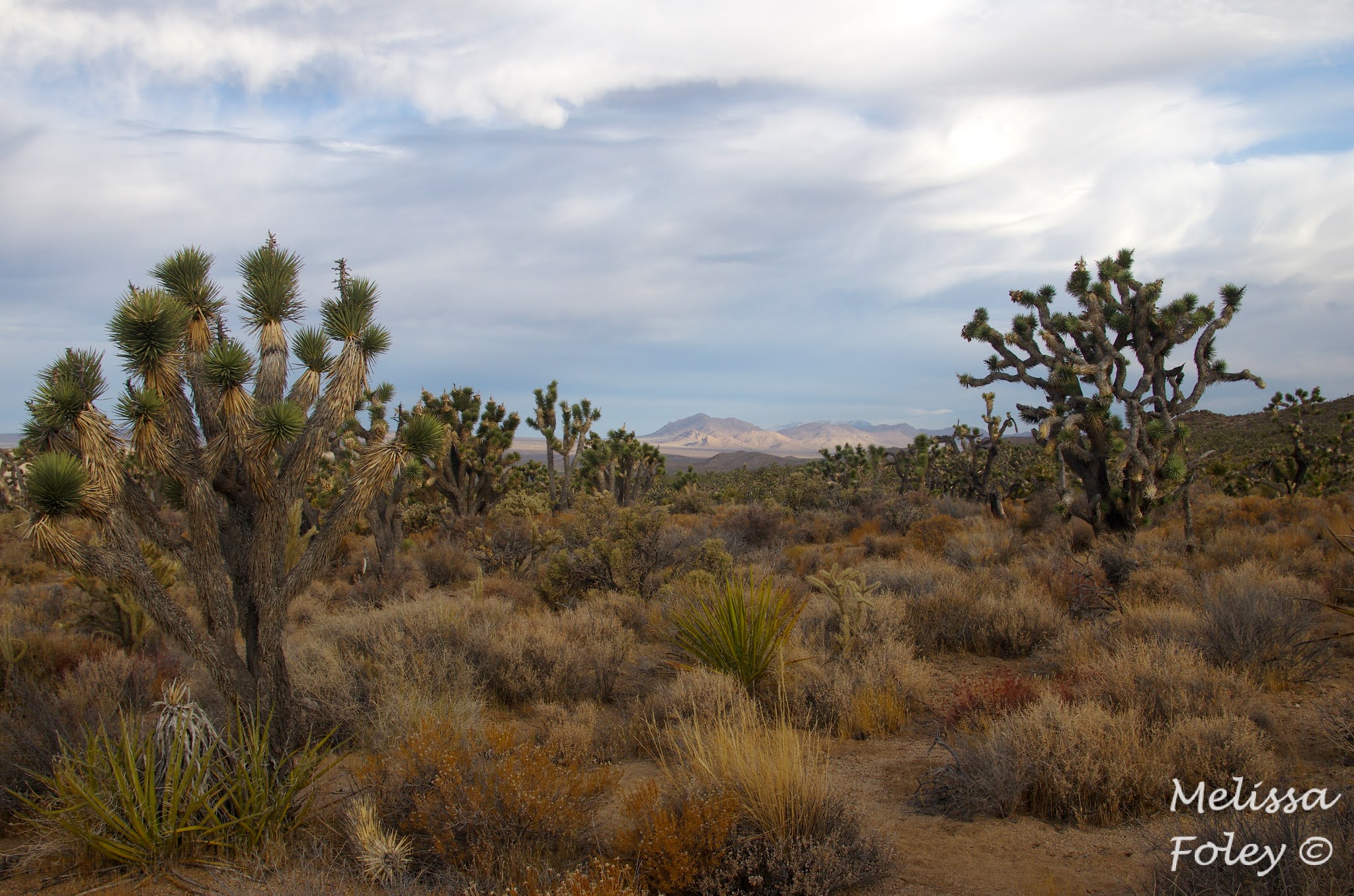
Our final stop on our eastern California tour was the Mojave National Preserve. Unlike Death Valley, the Mojave is mostly undeveloped with "wild" camping allowed in some areas of the park and few maintained trails. Contrary to what one might expect, Mojave has a higher density of Joshua trees than the national park to the south. The Mojave sits at a slightly higher elevation than Joshua Tree NP, providing better (wetter) conditions for the trees to grow and reproduce. The Mojave did not escape fire last summer either, and over a million trees were burned in the Dome Fire in the course of five days. While many of the charred trees were still standing when we were there, they are not fire adapted and will soon topple. In another story of climate change and invasive species (in this case a desert grass), baby Joshua trees will likely have a hard time recovering in this area, dealing another blow to a species that could disappear in our lifetimes.
We had two magnificent campsites to finish out our trip, one amongst giant granite formations and the other nestled into the Joshua tree forest. The Wish 5 is a great camping vehicle in most situations, but off-roading is not her forte. Regardless, we managed quite a few dirt roads and found some great spots despite our vehicular limitations. The stars in the Mojave were the most spectacular, helped along by a later rising moon. The nights were warmer too, allowing us to spend more time outside after dark. Our only official hike here was along the Hole in the Rock trail, which includes a narrow section of trail through a canyon and involves a number of ring holds to pull yourself up and through.


Eastern California is not Zambia, but it was a lovely adventure nonetheless. We were able to relax and unplug from the world (including the election results); we both came back healthy; and we were fortunate to get the trip in just before COVID numbers started skyrocketing and the state went back into lockdown.
1 comment:
LOve love love!
The Eastern Sierras are amazing.
Not Zambia, but I'm so glad you got out and explored.
Post a Comment