Sunday, May 7, 2023

Antelope Canyon 50-miler

Last August, in a moment of questionable judgement, I texted my sister and asked if she wanted to run 50 miles with me in northern Arizona in five months time. If I signed up, this would be my longest run by about 18 miles, but she had run this distance multiple times. I was looking for a bit of a sanity check from her because this was not a distance I was particularly excited about...it seemed far! But the 50k (31 miles) course did not include all of the best features of the course, including the infamous Antelope Canyon, which is not a place you can just rock up to on your own because it is located within the DinĂ© (Navajo) Nation. My sister quickly responded "yes!" so I registered us and panicked a bit after I clicked "submit."  

At the time that I signed us up for the trail run I had been running between 40-50 miles a week for a couple of years, so I had a good base. I looked at a lot of training plans and found one that seemed like a good mix of high mileage and rest weeks. For the next five months, I followed that as best I could while working full time, cleaning up from three floods, and losing access to a lot of local trails due to storm damage. I am pretty certain that shoveling mud after all the flooding was a good, albeit unwelcome, addition to my training regime. Having a lofty goal turned out to be a good motivator to stick with the plan even when it was rainy and cold outside. It turns out those training conditions were also fortuitous.

I met my sister in Las Vegas a few days before the run and we started our journey to Arizona by way of St. George, Utah. I did not know it at the time I planned our trip, but St. George is home to UltrAspire, a gear company that hosts my sister as one of their athletes. She contacted them before our arrival and they invited us to come see "where the magic happens." It was really neat to see how the mastermind behind the gear design and owner of the company, Bryce, designs and builds prototypes of all their gear. His passion for and commitment to his trade was inspiring.

Bryce (front), the creative behind UltrAspire

From St. George, we continued east to Page, Arizona, with a brief stop at Pipe Springs National Monument to stretch our legs and get some fresh air. Pipe Springs was a Mormon Outpost and hideout for polygamous wives in the late 1800s and later a stopover for travelers after the property was sold by the Mormon church. The cabins and "castle" still stand and the telegraph line that connected the ranch to Salt Lake City is still wired. The highlight of the site, in my opinion, is the trail around the site that winds through desert scrub with beautiful vistas. The common plants along the trail were identified on small plaques, first using the Paiute name followed by the english, a small nod to the original inhabitants of the land. 


We arrived in Page after crossing over the Glen Canyon Dam. The bathtub ring on Lake Powell that was about 150 feet above the water level was a stark reminder of the drought conditions the southwest has been enduring for more than a decade and all of the water issues that plague the Colorado River. I was definitely not in a drought mindset when we arrived because our neighborhood was in danger of flooding for the forth time and I was feeling a bit guilty about leaving Pete to deal with it on his own. Fortunately, we did not flood!

The day before our run was spent packing, checking, and rechecking our drop bags that we would be able to access along the course. I'm really good at making lists and then forgetting to look at them, but I knew I had to be diligent with these precious bags. We also had to get our drop bags to the race crew the morning before our run and wouldn't have a chance to access them again until we were on the course, so there wasn't an option to correct things if we forgot something. We were only preparing two drop bags, but we would access one of them twice. My bags included a wide variety of snacks (you never know what is going to taste good [or not] on a really long run), hydration powder, first aid, clothing, and any other gear I might need along the way, like a portable battery charger for my watch. While the aid stations have lots of snacks, many of them are not an option for me because they often contain gluten and/or dairy, so I had to be sure I could be self sufficient in the food department. The general rule of thumb is to consume 200-250 calories per hour. We were planning on a run time of around 12 hours, so I needed to have at least 2400 calories in my vest and drop bags. The course included a lot of sand, so we also included extra socks and shoes in case we needed a change. The extra socks ended up coming in handy for reasons other than you might expect. 


Saturday morning we were up bright and early for a 5:45 am start. We donned our headlamps and were off crossing the desert on our way to the first landmark of the day, Antelope Canyon. Just as we entered the beautiful and winding slot canyon, it started to sprinkle. The forecast for race day was a high in the low 60s, mostly overcast skies, and a 30% chance of rain (half inch or less). In other words, a pretty ideal forecast for a long day of running. That forecast ended up being very far from reality! 

looking a little sleepy, but ready to go


entrance to Antelope Canyon


We were not too daunted by the sprinkles at first, but then they became a bit more steady and just kept coming, and the temperature was stalled in the mid-50s. By the time we got to the second landmark, Horseshoe Bend on the Colorado River, the six miles of sandstone between there and the next aid station was a bit more slippery than usual, but we made it without incident. 


horseshoe bend, from the DinĂ© side

our route was often very close to the steep canyon walls
(the runner in black is my sister)

The third landmark, Waterhole Canyon, was the first low point of the day. As we neared the slot canyon, we found ourselves standing in a very slow moving line of fellow runners who were waiting to descend the 40-foot ladder into the canyon. It was cold and raining steadily at this point, so standing around for 30 minutes was pretty rough. When we finally got to the front of the line and dropped down into the canyon, large puddles had formed and water was sheeting off the side of the rock walls. When we were part way through the canyon, the race directors stopped allowing people into the canyon because of a flash flood warning. The canyon was beautiful, so at least there was that?! 
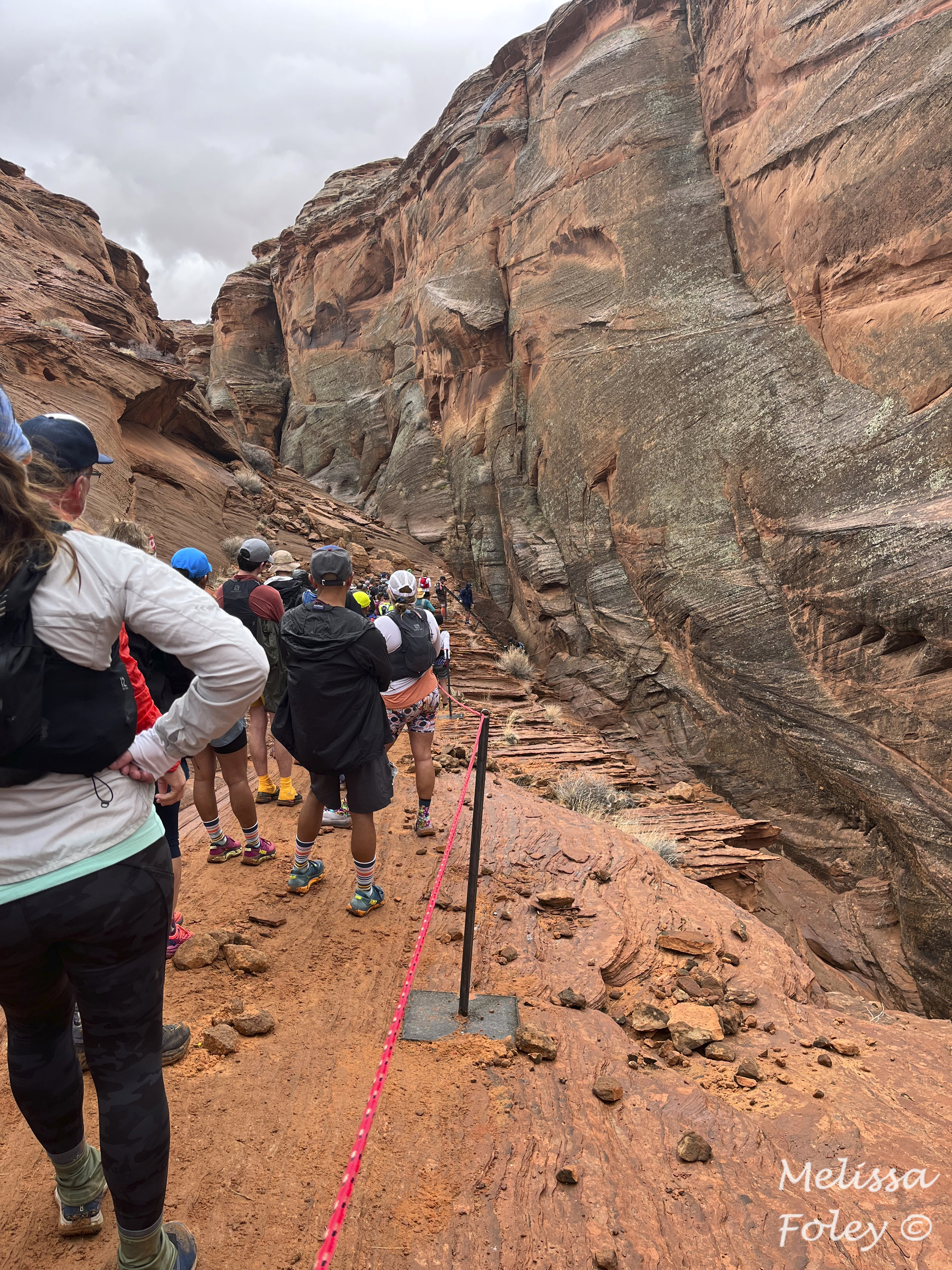
very long line at the ladder

somewhat sketchy ladder into the slot canyon


there were several ladders inside the canyon, too

official race photo...I just remember being so cold at this point

By the time we got to the aid station at mile 32, we were both wet and cold. Stephie swapped her wet, muddy mittens for a dry pair of sock mittens and I put on my calf sleeves, not because I needed the compression but because I needed the warmth. We drank some hot beverages (hot pickle juice anyone??) and continued onwards. As we started to cross the desert leading to the plateau that Page sits on, the washes that are typically dry had started to fill with water, meaning we had to do a few unplanned water crossings leading to even wetter shoes. As we tried to scramble up the mud-slick hill to the plateau, it became clear that we were not done with obstacles and that mud was in our future. 

The soil of the plateau, when wet, is at once slippery and sticky. The trail was a quagmire with more torrents to cross as water sheeted off the plateau in waterfalls. By this time, we were both quite cold and I noticed that my heart rate was around 90. At the time, I thought my watch was being finicky, so I didn't give it much thought. The trail finally got to some better drained soil making for easier running, but the wind was now blowing 15-20 mph. By the time we got to the last aid station of the run, we were both hypothermic but determined to finish. My sister was in worse shape than me, so we got a garbage bag at the aid station, cut a hole in it, and fashioned her a rain poncho. I had a shell on that had stopped being waterproof many miles ago, but it was still providing a bit of warmth. At this point, we had been on the course for 13 hours, so it was starting to get dark and we had 7.5 miles to go. The cutoff time for the run was 15 hours and my sister wanted me to get to the finish line before then, so she urged me to run off ahead of her. I had some trepidation in doing that since she was hypothermic, but she assured me the garbage bag was helping her warm up, so off I went. 

mud and waterfalls on the plateau

If this crappy winter did nothing else, it prepared me well for those last miles in the dark, cold, rain, mud, and wind. I was too cold to think about anything else, so I found my groove and crossed the finish line after 14 hours and 30 minutes. Stephie was still out there, though, so I turned around and headed back on the course to find her. At this point, I noticed that my heart rate was down to 60 bpm (while running), so I started to question the sanity of my decision to head back out. Soon I found my sister and we made it to the finish. There was a tent with heaters set up near the finish line, so we made a beeline for that while race volunteers gave us hot food and drinks to help us warm up. We were both so cold that we didn't last long there in favor of getting back to the hotel and hot showers. 

we made it!!!

It was a doozy of a first 50-miler for me, and I'm proud that we persevered through all the conditions the day threw at us. The race directors said it was the least accurate forecast they have ever seen for a race. We were not the only ones caught out by the conditions and many people dropped mid-race instead of slogging it out. Fortunately the scenery was beautiful! 

We took our time driving back to St. George so we could keep our leg muscles from getting too stiff and sore. We stopped at Marble Canyon to see the condors (success!) and enjoyed one of the many lovely trails in St. George. As always, the best part of this adventure was getting to spend time with my sister doing something we both love. 

marble canyon


Monday, July 11, 2022

Ramblings in Wales and England

We had a few days on either side of our narrowboat adventure to explore northern Wales and a bit of England. Our first stop was in Oxford, England, a couple hours north of London. Other than enjoying the architecture and history of the city, we didn't have anything planned for our two days there. Getting there was an adventure in itself. After realizing that train travel in the UK is not the economical option like it is on the continent, we picked up a one-way rental car in London. Pete braved the London traffic and narrow Oxfordshire roads while I tried to navigate us through the sometimes incredibly confusing stacks of roundabouts. Our B&B in Oxford was a bit outside the city centre and well situated for evening strolls along the River Thames and to all the main Oxford attractions. 

As we wandered around the town marveling at the loveliness of the buildings and spring gardens, Pete was picking up pieces of passing conversations about an event happening the next morning. After a bit of internet searching, we realized people planning for May Morning, the annual May Day celebration in Oxford, which was taking place the next day. May Morning celebrations were cancelled the previous two years because of covid and May 1st was a Sunday that coincided with a long bank holiday weekend, so the crowd was expected to be quite large. We were not quite sure what we were getting ourselves into, but we woke at 5 am and joined the gathering  stream of pedestrians heading toward Magdalen Bridge. We found a spot on the edge of the gathering crowd (estimated to be over 12,500 people) where we had a relatively good view of Magdalen Tower. The Magdalen College Choir stands atop the tower and sings a hymn promptly at 6 am, a tradition going back over 500 years. As the bells tolled at 6 am, the susurrus of the crowd immediately stopped. It was silent when the choir sang the first note. It was incredible. Everyone stood in silent awe as the voices rang out from the tower. After a prayer for "town" and "gown" (Oxford City and Oxford College) and another selection from the choir, the bells began to peal as the crowd processed up High Street where Morris dancers and musicians of all types carried on the festivities. We watched the merriment for a bit and then walked back to our B&B for a short nap before heading north to visit friends.  

Christ Church

Spring in Oxford was lovely 
(photo by Pete)

Bodleian Library

Bodleian Library - imagine attending lectures in here!

Radcliffe Camera

Magdalen Tower (singers on top for May Morning)

Morris dancers

Morris dancers in action surrounded by a large crowd

After our week on the narrowboat, we headed to northern Wales. Our first stop was Llangollen, where we stayed at an amazing hotel situated between the River Dee and the head of the Llangollen branch of the Shropshire and Union Canal. Because we were no longer cooking most of our meals, I had to be on the lookout for places that could cater to my gluten- and dairy-free dietary needs. One of the traditional English foods that I knew would be difficult for me to find was fish and chips. During a bit of pre-trip sleuthing, I found a place in Llangollen that came highly recommended from the gluten-free crowd and fish and chips were on the menu. The setting and the food were delightful! 


view of the River Dee from our room 

Chainbridge Hotel and connecting chain bridge
(photo by Pete)


Our real reason for the stop in Llangollen was to see the nearby Pontcysyllte Aqueduct that is one of the World Heritage structures along the Llangollen Canal. The Aqueduct (bridge of water over water) was completed in 1805 and consists of 18 stone arches that rise 126 feet above the River Dee, the tallest aqueduct in the world. The cast iron trough that sits atop the arches is 337 yards long, 12 feet wide, and 5 feet deep. There is a (very narrow!) tow path on one side of the canal and nothing but a very long drop on the other. We walked across multiple times and watched many narrowboats pass through. It is a beautiful structure to behold, particularly from vantage points further afield that let you see the whole thing at once. 

trough of water over the River Dee


narrowboat traveling across the aqueduct 100 feet above the ground

within about 10 years of the aqueduct's completion, steam trains
took over much of the goods transport so the railway bridge
in the distance saw much more use than the aqueduct

We next stationed ourselves in the bustling town of Betws-y-Coed on the edge of Snowdonia National Park for a couple of days. From there we explored two of the many castles dotted around Northern Wales from the days of King Edward I (late 1200s). The heavily fortified castles in Conwy and Caernarfon, two of the four included in the World Heritage listing for their military architecture, are still quite intact, featuring my favorite medieval defenses - barbicans and murder holes. The two castles were also naturally defended on two sides by their respective rivers and estuaries. While strategic, these also made for beautiful settings with views of water and the surrounding hills from every vantage point. The town walls are also still largely intact, particularly in Conwy, which were fun to explore. Caernarfon was the only one of the castles properly lived in by King Edward I's family. The other three were still being completed when they were besieged by the Welsh during the early 1300s. Caernarfon was also seized but was taken back by the royal family in the 1600s and eventually taken over by the government for maintenance and repairs. In recent times, the castle has the site for the investiture of the Prince of Wales in 1911 for Prince Edward VIII and 1969 for Prince Charles.

Eight towers of Conwy connected by walls and spiral staircases
(photo by Pete)


standard photo of Pete at the archer station


the medieval public toilet block

town walls and towers surround the center of Conwy

Caernarfon on the River Seiont

one of the many splendid towers at Caernarfon

internal hallway connecting the towers, a rare 
feature not seen in most defunct castles

Pete wishing someone would make him a Prince
(or at least a knight)

the town walls in Caernarfon are used as roads in some areas

We also managed a few hikes while we were in the north. There are many trails around Betws-y-Coed in Gwydir forest, which were great for a morning run or late afternoon ramble, even if they are steep. In one section of the forest, there were dedicated mountain bike routes. As a runner, I loved this idea. There have been may times where I have nearly been run over by mountain bikes racing down a hill that are not expecting to encounter me coming around a corner. Between Caernarfon and Betws-y-Coed, we hiked around Llyn Idwal, a beautiful glacial lake at the base of a hanging valley. It was our only up close glimpse of the beauty of Snowdonia and the slate landscape that dominates the western side of the park. The slate was put to good use on the Llyn Idwal walking path, with giant slabs used to make small bridges across streams. 

the sign that greeted us at the start of our walk to Llyn Elsi
(photo by Pete)

the final sign...there were a few signs in between with updates 
on distance and corresponding changes in facial expressions
(photo by Pete)

morning run in Gwydir

view of Tryfan from Pont Pen-y-Benglog

the light wasn't fantastic, but the scenery was

trail to Cym Idwal

when in slate country, you may as well use
a massive slab of slate for the bridge
(photo by Pete)

Our final day in northern Wales was spent riding the oldest narrow gauge steam train in the world from Porthmadog to Tan-y-Bwlch. I had hoped to get tickets on the train that went all the way to Blaenau Ffestiniog, one of the centers of slate mining, but the trip was sold out. Our drive from Betws-y-Coed, however, took us through Blaenau Ffestiniog, so we got to see the slate quarry and hillsides rising above the town anyway. Porthmadog is a lovely coastal town next to the edge of the estuary, with the hills of Snowdonia rising to the northeast. Our coal-fed steam train chugged up the hill through woodlands and small villages for about an hour before we disembarked at Tan-y-Bwlch. We had about 45 minutes there before the return trip, so we walked down to Llyn Mair, keeping our eyes out for otters (no such luck). The steam engine was quite lovely and a fair bit smaller than the ones operating on the narrow gauge tracks a couple miles from our house. The rail line was originally built to move slate from the quarries around Blaenau Ffestiniog to ships in Porthmadog. The line was graded such that the journey from the quarries to the port was all downhill because horses were originally used to pull the carts. There were some very narrow sections where cuts in the hillsides were made just wide enough for the carts to pass through. Steam engines replaced the horses in the mid-1800s as production at the quarries continued to increase. The standard gauge railway eventually surpassed the narrow gauge in transporting slate; the narrow gauge tracks have predominantly been used for tourism since the 1950s.   

Our lovely engine for the day, Prince


lovely woodland views from our carriage

very tight spaces!

Wales and her people were lovely. I look forward to returning and getting a different take of the country than the very colonist-centric view we got this time. While the Scottish get most of the props today for their views on independence from England and the crown, the Welsh also have a long history of fighting for independence and a unique culture that is quite different from the rest of the countries in the UK. While in the States we only need to look back a few hundred years to delve into the history of our traditional people and cultures, it requires a much, much longer trip to the past (3500 BC) to understand the history and the many shifts in culture that have occurred on that small island in the North Atlantic. 

On our way back to London, we decided on a route that took us through Bath, England, to see the Roman Baths. We stayed outside the city proper at a guest house and pub that turned out to be perfectly situated for catching the bus into Bath. Navigating the narrow streets and parking situation were not high on our list of travel goals! 

The baths were built in the 1st century AD by the Romans using the natural thermal properties of the area to create a spa and temple. The city of Bath is centered around the old city of Aquae Sulis, which has been largely preserved. The hot water stills flows into the largest bath as it did 2000 years ago. Kind of spectacular! The Georgian architecture found all over the city, which was a much later addition in the 1700s, is beautiful and much more reminiscent of cities in Europe than the UK. We had a nice time exploring the baths and the city. This last stop brought our World Heritage site count for the trip to seven. Besides the Roman baths, most were focused around the country's industrial landscape (coal, slate, iron). While interesting to see, those sites have a bit less appeal for me than the sites of culture or natural significance we usually visit.    

Pulteney Bridge, built in 1774 and one of the few in
the world that has shops built into the bridge on both sides 
(photo by Pete)


the main and largest bath from above


original hot spring feeding the bath

Bath Abbey - most recently updated in the 1830s but on 
the site of some form of church for over 1000 years

stained glass panel devoted to King George, who played a large 
role in putting Bath on the map as a major center for the arts

lovely ceiling architecture

Support for Ukraine was everywhere, from London to the 
smallest villages. It was heartening and heartbreaking. 

Our drive back to London was uneventful and we passed our covid tests so were allowed to travel home. That hurdle had given me some anxiety during our travels, particularly in our last week when we were around more people than we were on the narrowboat. Fortunately for us, the omicron wave had gone through the UK before we arrived and the BA.5 variant had yet to arrive. Yet another international trip where we managed to get in and out just in time...